


Before visiting, please check the conditions of access.
 Walking/running/hiking
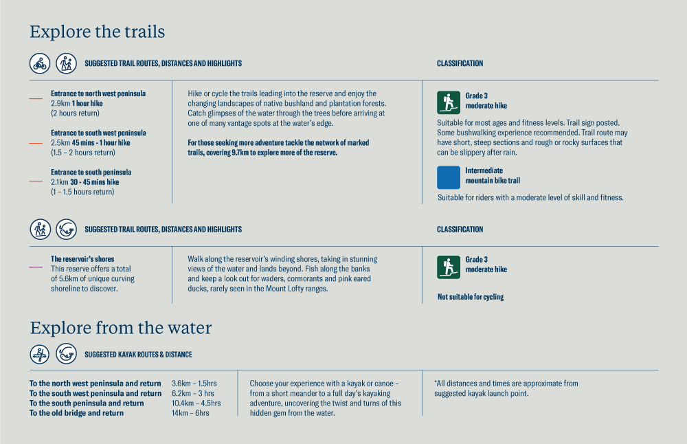
With a range of tracks on offer, you can explore on foot through a changing landscape of native bushland and plantation forests. The paths are graded as a moderate hike and are suitable for most ages and fitness levels. There are some steep sections and rough/rocky surfaces.
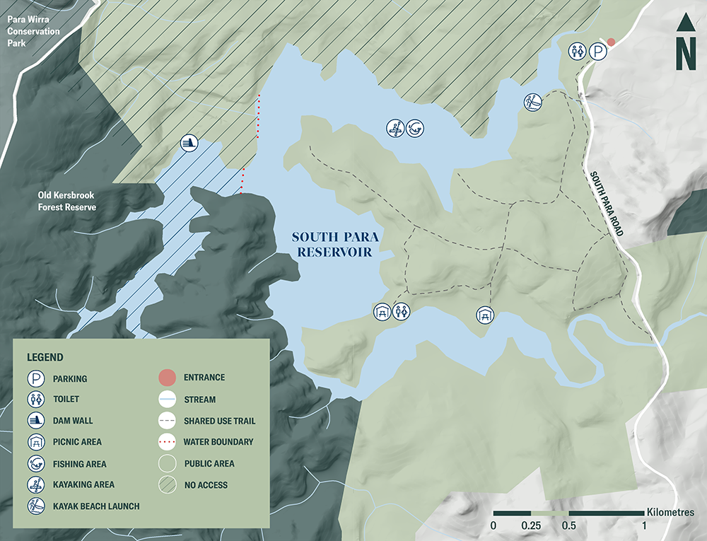
From the entrance to the north west peninsula is 2.9km, or you can head to the south west peninsula (2.5km) and south peninsula (2.1km). Pack a picnic and explore these shared use trails leading to water views. The reserve boasts a total of 8.7 km of trail.
You can also walk along the reservoir's winding shores, taking in stunning views of the water and lands beyond. Look out for waders, cormorants and pink eared ducks, a rare sight in the Mount Lofty Ranges.

Navigate the reserve with the free Avenza app
Download the South Para Reservoir Reserve map
 Fishing
With a fishing permit, you can drop a line in the from the shoreline in the public access area or on the water from a kayak or canoe. Be sure to take your insect repellent.
The reservoir is stocked with Murray cod (catch and release), golden perch and silver perch. Fishing limits are detailed on PIRSA's website.
 Cycling
The shared use trails offer intermediate mountain biking suitable for riders with a moderate level of skill and fitness. Explore the trails as they pass through a changing landscape of native bushland and plantation forests. You will catch glimpses of the water through the trees before arriving at one of many vantage spots at the water's edge.
Navigate the reserve with the free Avenza app
Download the South Para Reservoir Reserve map
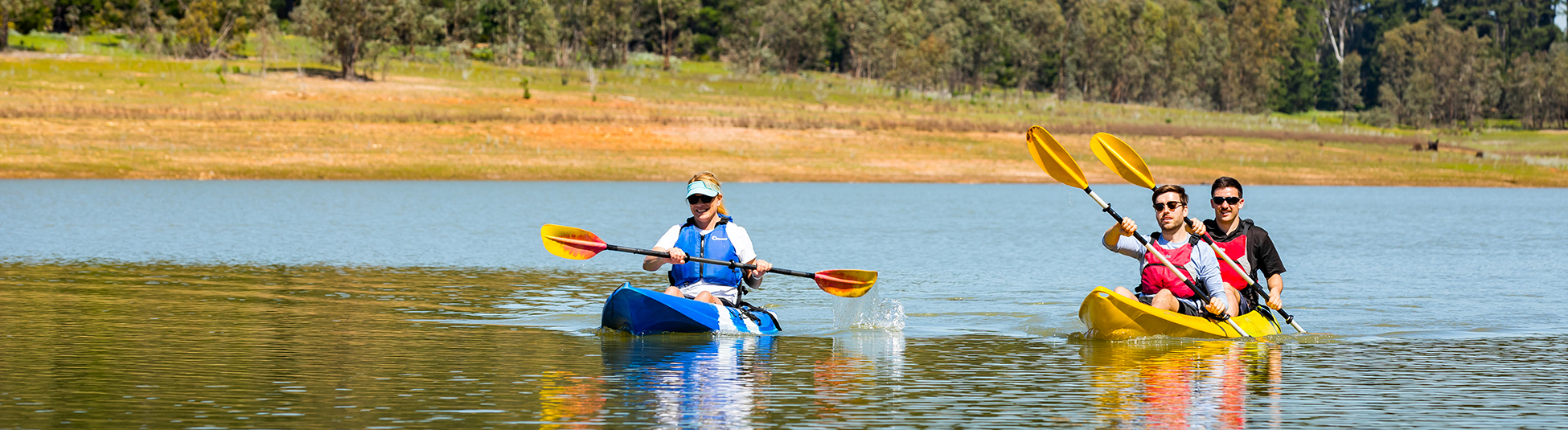
 Kayaking/canoeing
Choose your experience with a kayak or canoe, from a short meander to a full day's kayaking adventure exploring the twists and turns of this hidden gem from the water.
During the warmer months when the reservoir's level can be low, bring a trolley to get your kayak or canoe to the water's edge more easily.
Suggested routes include:
- to the north west peninsula - 3.6km return, approx. 1.5 hours
- to the south west peninsula - 6.2km return, approx. 3 hours
- to the south peninsula - 10.4km return, approx. 4.5 hours
- to the old bridge - 14km return, approx 6 hours.
Be sure to take your insect repellent.
 Picnicking
The two picnic spots offer a place to sit back and enjoy the water views. Walk, run, ride or kayak to the south west peninsula and the south peninsula for a picnic, with toilets available at the south west peninsula.
![]() Dogs are not welcome at reservoir reserves as they can carry harmful organisms that can easily contaminate the water and they pose a threat to local native birds and wildlife. Assistance animals are accepted.
Dogs are not welcome at reservoir reserves as they can carry harmful organisms that can easily contaminate the water and they pose a threat to local native birds and wildlife. Assistance animals are accepted.
Blue-green algae
Algae is a common occurrence in open water sources, including reservoirs and the River Murray, especially during warmer months of the year when conditions are favourable for growth.
SA Water samplers, operators and scientists actively monitor and test the source water and connecting water networks during these times and adjust treatment processes as needed. This ensures they continue to supply safe, clean drinking water to their customers.
Some blue-green algae species produce compounds which can be harmful to humans and animals. Contact with untreated water in a reservoir where algae are present can be harmful to your health.
When blue-green algae levels are increasing, and related water treatment or algal management activities are being conducted, the site will be closed to visitors until 1pm that day. There will be clear signage at the entrance and on this website page.
To find out more, read SA Health’s information about blue-green algae health impacts and how to avoid illness
Free offline maps
Use the free Avenza app to navigate around the reservoir reserve, record your GPS tracks or enjoy other features. Download the map to your mobile device and you can access it even without mobile coverage.
Download the South Para Avenza map here.
Click map and map details below for a print-friendly version.